Agribase ยท Satellite fire alerts
The difference is how soon you know. Fuoco in Zona checks your land via satellite every 5 minutes and alerts you on Telegram or email as soon as it detects a fire within the radius you choose.
Join the free beta โFree until June 20, 2027. No card required.
Being home at the right moment. A neighbor who spots the smoke and calls. Checking a list of fires by hand every day. That's not a defense system โ it's the absence of one.
hectares burned in Italy compared to the 20-year average for the same period โ data as of August 26, 2026, source: EFFIS/Copernicus.
We don't just tell you โ we show you. Here's exactly what you'll see.
Click the spot on the map, paste a Google Maps link, or โ if you run a farm business in Puglia โ enter the sheet and parcel number and see the real cadastral outline before confirming. No technical skill required.
The radius is measured as the crow flies, not by road โ we're upfront about that, because a fire 8 km away in a straight line can be much farther if you had to drive there. Change it anytime, in a second.
monitoring radius, as the crow flies
Exact distance from your land. Fire intensity. How much you can trust the reading (we always tell you, even when the false-alarm risk is high). Wind direction and speed, with a satellite image showing where it's heading โ and if we know your cadastral data, your land's real outline drawn on top. Everything explained in plain language โ never an acronym you don't understand.
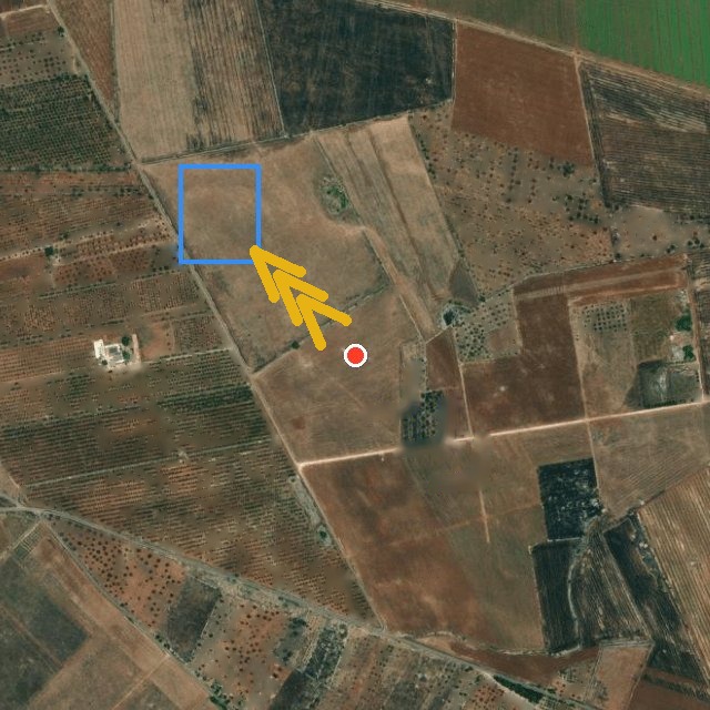
The fire maps you find elsewhere ask you to go check them yourself. Fuoco in Zona comes to you โ the difference isn't extra features, it's that you don't have to remember to look.
Live fire maps only work if you remember to check them. Fuoco in Zona writes to you on Telegram or email the moment there's something โ zero effort, nothing to remember.
We also use the European Meteosat satellites, which update every 10-15 minutes โ not just NASA's passes, which fly over an area only once or twice a day.
You know if the fire is heading toward you, and you see your land's real boundary drawn on the satellite image โ not just a pin on a generic map.
It arrives on Telegram or email, where you already are. Not another app to download and remember to open.
If the false-alarm risk is high, we tell you. If the wind could shift, we tell you. An alert that hides its limits is worth exactly as much as no alert at all.
Something we'd rather tell you upfront: we check every 5 minutes, and Meteosat (the European source) updates almost in real time โ but NASA, which covers everything else, sometimes publishes its data with a delay of a few hours, simply because of how its global system works. That's not something we're hiding: it's a real limit on NASA's side, and we'd rather tell you than promise a speed we can't always deliver.
We're working every day to make the system faster โ the goal is to get as close to real time as possible. Because what matters to us isn't the technology itself, it's actually protecting the land.
Why it exists
Fuoco in Zona isn't a case study dreamed up on paper. It was built to monitor a family farm in Puglia โ built and tested with real satellite data, one piece at a time, with real bugs fixed as they came up. We use it ourselves, every day, on our own land.
A public, free commitment
Beyond the alerts for your own land, we publish every wildfire detected by satellite in Italy for free โ with municipality, land-registry sheet, parcel, and estimated land cover, to check whether a municipality has registered the burned area as required by law (L.353/2000). We also explain how to do it, step by step. No cost, no sign-up required.
โฆ
wildfires detected by satellite in Italy since January 1, 2026 โ historical archive still being completed
See the public map โChoose monthly if you only need the fire season. Choose annual if you want peace of mind all year.